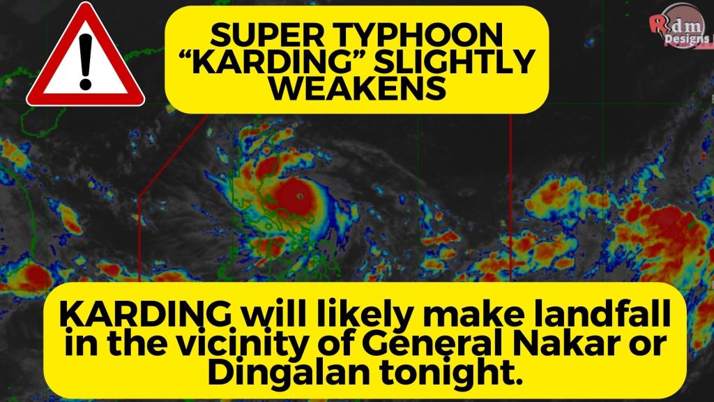
•Location of Center (7:00 PM) The center of the eye of Super Typhoon KARDING was estimated based on all available data including those from Daet, Baler, and Tagaytay Doppler Weather Radars over the coastal waters of General Nakar, Quezon (15.1°N, 121.7°E)
•Intensity Maximum sustained winds of 185 km/h near the center, gustiness of up to 255 km/h, and central pressure of 925 hPa
•Present Movement Westward at 20 km/h •Extent of Tropical Cyclone Winds Strong to typhoon-force winds extend outwards up to 290 km from the center
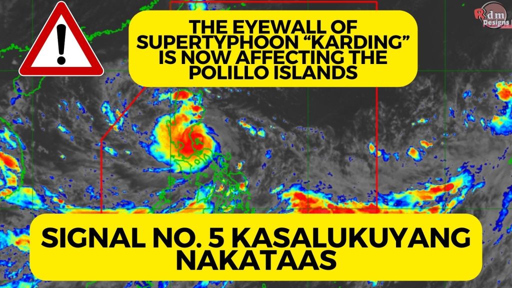
THE EYEWALL OF “KARDING” IS NOW AFFECTING THE POLILLO ISLANDS
•Location of Center (4:00 PM)
The center of the eye of Super Typhoon KARDING was estimated based on all available data including those from Daet and Baler Doppler Weather Radars over the coastal waters of Burdeos, Polillo Islands, Quezon (15.0°N, 122.1°E)
•Intensity Maximum sustained winds of 195 km/h near the center, gustiness of up to 240 km/h, and central pressure of 920 hPa
•Present Movement Westward at 20 km/h
•Extent of Tropical Cyclone Winds Strong to typhoon-force winds extend outwards up to 290 km from the center
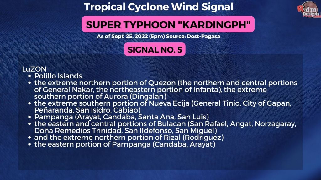
Super Typhoon #KardingPH -Signal No. 5 – TCWS No. 5
LUZON
Polillo Islands
the extreme northern portion of Quezon (the northern and central portions of General Nakar, the northeastern portion of Infanta), the extreme southern portion of Aurora (Dingalan)
the extreme southern portion of Nueva Ecija (General Tinio, City of Gapan, Peñaranda, San Isidro, Cabiao)
Pampanga (Arayat, Candaba, Santa Ana, San Luis)
the eastern and central portions of Bulacan (San Rafael, Angat, Norzagaray, Doña Remedios Trinidad, San Ildefonso, San Miguel)
and the extreme northern portion of Rizal (Rodriguez)
the eastern portion of Pampanga (Candaba, Arayat)
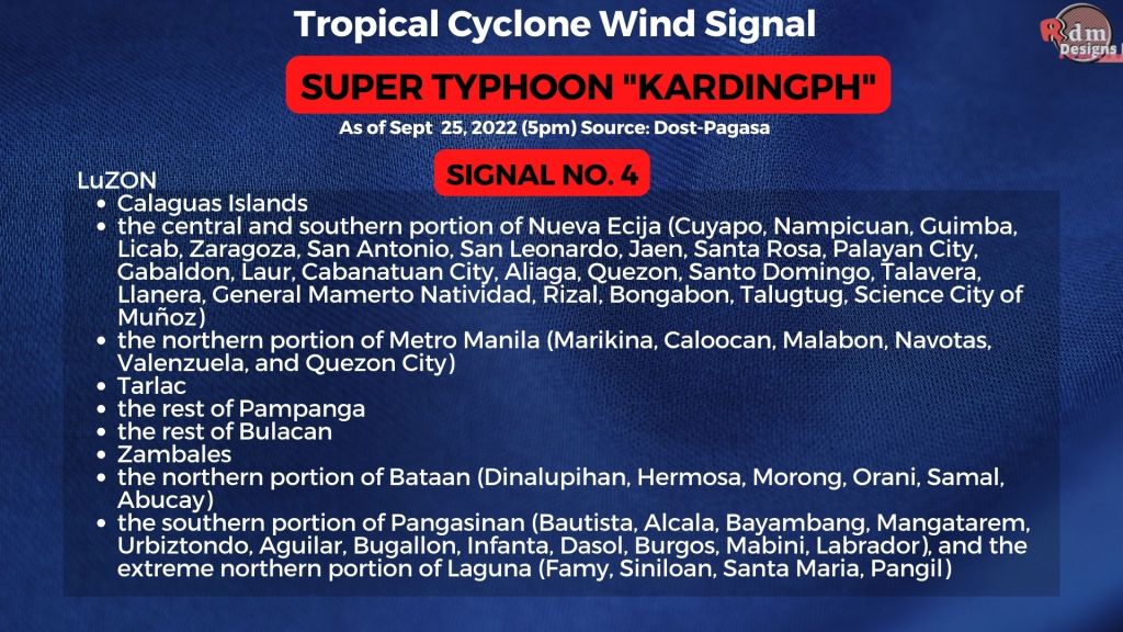
Super Typhoon #KardingPH -Signal No. 4 – TCWS No. 4
LUZON
Calaguas Islands
the central and southern portion of Nueva Ecija (Cuyapo, Nampicuan, Guimba, Licab, Zaragoza, San Antonio, San Leonardo, Jaen, Santa Rosa, Palayan City, Gabaldon, Laur, Cabanatuan City, Aliaga, Quezon, Santo Domingo, Talavera, Llanera, General Mamerto Natividad, Rizal, Bongabon, Talugtug, Science City of Muñoz)
the northern portion of Metro Manila (Marikina, Caloocan, Malabon, Navotas, Valenzuela, and Quezon City)
Tarlac
the rest of Pampanga
the rest of Bulacan
Zambales
the northern portion of Bataan (Dinalupihan, Hermosa, Morong, Orani, Samal, Abucay)
the southern portion of Pangasinan (Bautista, Alcala, Bayambang, Mangatarem, Urbiztondo, Aguilar, Bugallon, Infanta, Dasol, Burgos, Mabini, Labrador), and the extreme northern portion of Laguna (Famy, Siniloan, Santa Maria, Pangil)
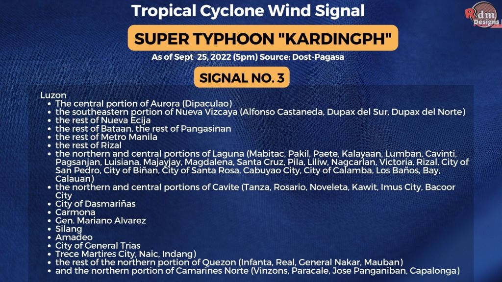
Super Typhoon #KardingPH -Signal No. 3 – TCWS No. 3
Luzon
The central portion of Aurora (Dipaculao)
the southeastern portion of Nueva Vizcaya (Alfonso Castaneda, Dupax del Sur, Dupax del Norte)
the rest of Nueva Ecija
the rest of Bataan, the rest of Pangasinan
the rest of Metro Manila
the rest of Rizal
the northern and central portions of Laguna (Mabitac, Pakil, Paete, Kalayaan, Lumban, Cavinti, Pagsanjan, Luisiana, Majayjay, Magdalena, Santa Cruz, Pila, Liliw, Nagcarlan, Victoria, Rizal, City of San Pedro, City of Biñan, City of Santa Rosa, Cabuyao City, City of Calamba, Los Baños, Bay, Calauan)
the northern and central portions of Cavite (Tanza, Rosario, Noveleta, Kawit, Imus City, Bacoor City
City of Dasmariñas
Carmona
Gen. Mariano Alvarez
Silang
Amadeo
City of General Trias
Trece Martires City, Naic, Indang)
the rest of the northern portion of Quezon (Infanta, Real, General Nakar, Mauban)
and the northern portion of Camarines Norte (Vinzons, Paracale, Jose Panganiban, Capalonga)
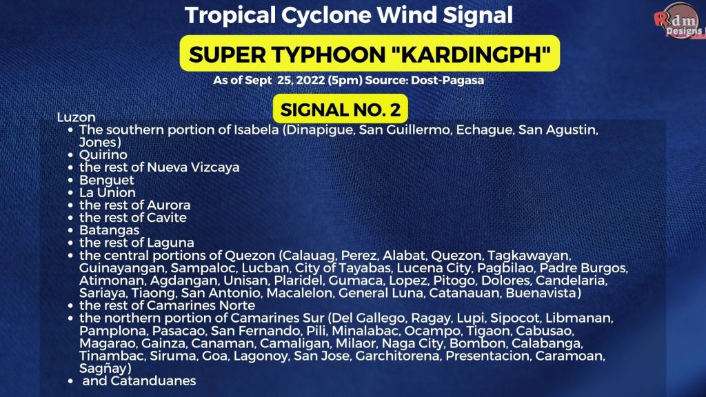
Super Typhoon #KardingPH -Signal No. 2 – TCWS No. 2
Luzon
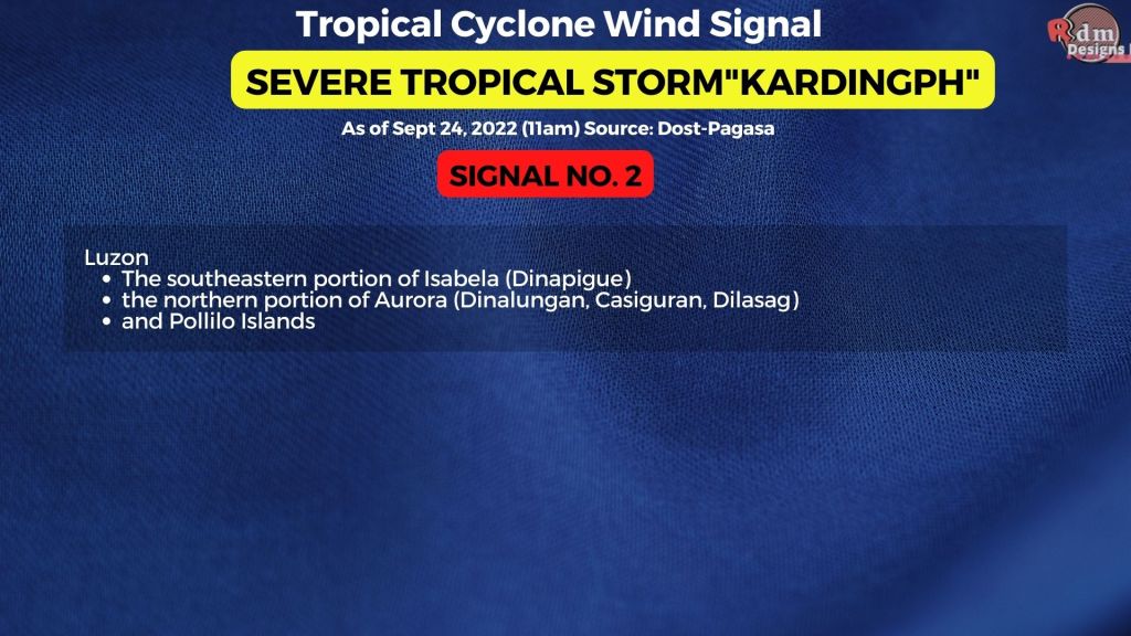
The southern portion of Isabela (Dinapigue, San Guillermo, Echague, San Agustin, Jones)
Quirino
the rest of Nueva Vizcaya
Benguet
La Union
the rest of Aurora
the rest of Cavite
Batangas
the rest of Laguna
the central portions of Quezon (Calauag, Perez, Alabat, Quezon, Tagkawayan, Guinayangan, Sampaloc, Lucban, City of Tayabas, Lucena City, Pagbilao, Padre Burgos, Atimonan, Agdangan, Unisan, Plaridel, Gumaca, Lopez, Pitogo, Dolores, Candelaria, Sariaya, Tiaong, San Antonio, Macalelon, General Luna, Catanauan, Buenavista)
the rest of Camarines Norte
the northern portion of Camarines Sur (Del Gallego, Ragay, Lupi, Sipocot, Libmanan, Pamplona, Pasacao, San Fernando, Pili, Minalabac, Ocampo, Tigaon, Cabusao, Magarao, Gainza, Canaman, Camaligan, Milaor, Naga City, Bombon, Calabanga, Tinambac, Siruma, Goa, Lagonoy, San Jose, Garchitorena, Presentacion, Caramoan, Sagñay)
and Catanduanes
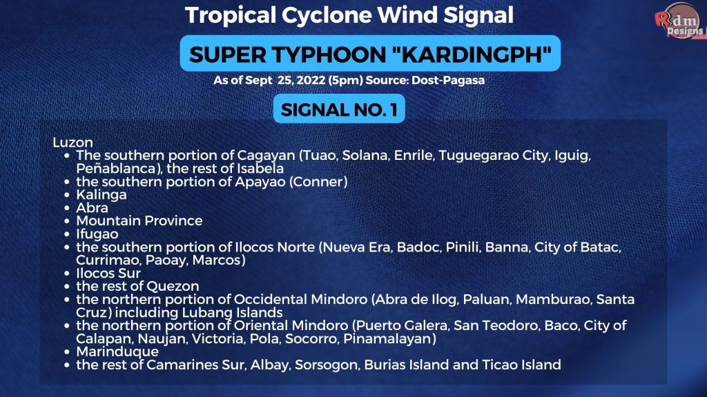
Super Typhoon #KardingPH -Signal No. 1 – TCWS No. 1
Luzon
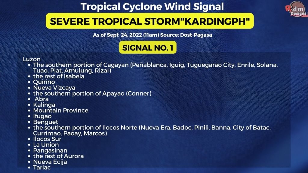
The southern portion of Cagayan (Tuao, Solana, Enrile, Tuguegarao City, Iguig, Peñablanca), the rest of Isabela
the southern portion of Apayao (Conner)
Kalinga
Abra
Mountain Province
Ifugao
the southern portion of Ilocos Norte (Nueva Era, Badoc, Pinili, Banna, City of Batac, Currimao, Paoay, Marcos)
Ilocos Sur
the rest of Quezon
the northern portion of Occidental Mindoro (Abra de Ilog, Paluan, Mamburao, Santa Cruz) including Lubang Islands
the northern portion of Oriental Mindoro (Puerto Galera, San Teodoro, Baco, City of Calapan, Naujan, Victoria, Pola, Socorro, Pinamalayan)
Marinduque
the rest of Camarines Sur, Albay, Sorsogon, Burias Island and Ticao Island
KardingPh REACHES SUPER TYPHOON CATEGORY AFTER A PERIOD OF EXPLOSIVE INTENSIFICATION.
• Location of Center (7:00 AM):
The center of the eye of Super Typhoon KARDING was estimated based on all available data including those from Daet and Baler Doppler Weather Radars at 230 km East of Infanta, Quezon (15.0°N, 123.8°E)
The southern portion of Cagayan (Peñablanca, Iguig, Tuguegarao City, Enrile, Solana, Tuao, Piat, Amulung, Rizal), the rest of Isabela, Quirino, Nueva Vizcaya, the southern portion of Apayao (Conner), Abra, Kalinga, Mountain Province, Ifugao, Benguet, the southern portion of Ilocos Norte (Nueva Era, Badoc, Pinili, Banna, City of Batac, Currimao, Paoay, Marcos), Ilocos Sur, La Union, Pangasinan, the rest of Aurora, Nueva Ecija, Tarlac
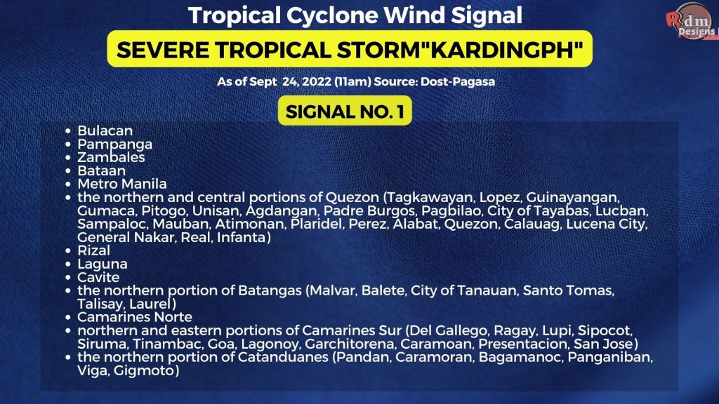
, Bulacan, Pampanga, Zambales, Bataan, Metro Manila, the northern and central portions of Quezon (Tagkawayan, Lopez, Guinayangan, Gumaca, Pitogo, Unisan, Agdangan, Padre Burgos, Pagbilao, City of Tayabas, Lucban, Sampaloc, Mauban, Atimonan, Plaridel, Perez, Alabat, Quezon, Calauag, Lucena City, General Nakar, Real, Infanta), Rizal, Laguna, Cavite, the northern portion of Batangas (Malvar, Balete, City of Tanauan, Santo Tomas, Talisay, Laurel), Camarines Norte, northern and eastern portions of Camarines Sur (Del Gallego, Ragay, Lupi, Sipocot, Siruma, Tinambac, Goa, Lagonoy, Garchitorena, Caramoan, Presentacion, San Jose), and the northern portion of Catanduanes (Pandan, Caramoran, Bagamanoc, Panganiban, Viga, Gigmoto)
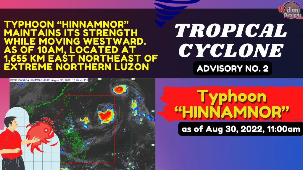
TYPHOON “HINNAMNOR” MAINTAINS ITS STRENGTH WHILE MOVING WESTWARD. Location of Center (10:00 AM) The center of the eye of Typhoon “HINNAMNOR” was estimated based on all available data at 1,655 km East Northeast of Extreme Northern Luzon (26.8°N, 136.7°E) Via: DOST PAGASA
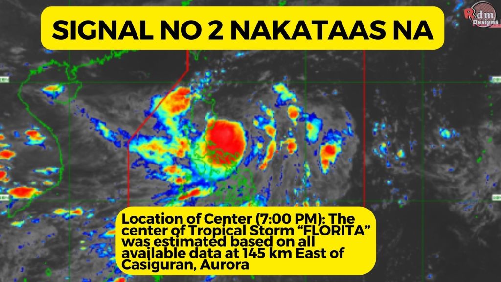
TROPICAL STORM “FLORITA” CONTINUES TO MAINTAIN ITS STRENGTH WHILE MOVING SLOWLY WESTWARD OVER THE PHILIPPINE SEA.
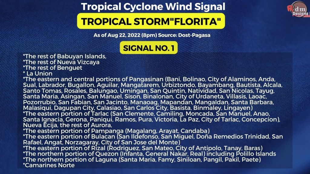
Location of Center (7:00 PM): The center of Tropical Storm “FLORITA” was estimated based on all available data at 145 km East of Casiguran, Aurora (16.2°N, 123.5°E) Intensity: Maximum sustained winds of 75 km/h near the center, gustiness of up to 90 km/h, and central pressure of 996 hPaTROPICAL STORM FLORITA – SIGNAL NO. 1 *The rest of Babuyan Islands, *The rest of Nueva Vizcaya *The rest of Benguet * La Union *The eastern and central portions of Pangasinan (Bani, Bolinao, City of Alaminos, Anda, Sual, Labrador, Bugallon, Aguilar, Mangatarem, Urbiztondo, Bayambang, Bautista, Alcala, Santo Tomas, Rosales, Balungao, Umingan, San Quintin, Natividad, San Nicolas, Tayug, Santa Maria, Asingan, San Manuel, Sison, Binalonan, City of Urdaneta, Villasis, Laoac, Pozorrubio, San Fabian, San Jacinto, Manaoag, Mapandan, Mangaldan, Santa Barbara, Malasiqui, Dagupan City, Calasiao, San Carlos City, Basista, Binmaley, Lingayen) *The eastern portion of Tarlac (San Clemente, Camiling, Moncada, San Manuel, Anao, Santa Ignacia, Gerona, Paniqui, Ramos, Pura, Victoria, La Paz, City of Tarlac, Concepcion), Nueva Ecija, the rest of Aurora, *The eastern portion of Pampanga (Magalang, Arayat, Candaba) *The eastern portion of Bulacan (San Ildefonso, San Miguel, Doña Remedios Trinidad, San Rafael, Angat, Norzagaray, City of San Jose del Monte) *The eastern portion of Rizal (Rodriguez, San Mateo, City of Antipolo, Tanay, Baras) *The northern portion of Quezon (Infanta, General Nakar, Real) including Polillo Islands *The northern portion of Laguna (Santa Maria, Famy, Siniloan, Pangil, Pakil, Paete) *Camarines NorteTROPICAL STORM FLORITA – SIGNAL NO. 2 *Cagayan *The southern portion of Babuyan Islands (Camiguin Is., Fuga Is.) *Isabela *Quirino *The eastern and central portions of Nueva Vizcaya (Kayapa, Ambaguio, Solano, Villaverde, Bagabag, Diadi, Quezon, Bayombong, Bambang, Aritao, Dupax del Sur, Dupax del Norte, Kasibu, Alfonso Castaneda) *Apayao *Abra *Kalinga *Mountain Province *Ifugao *The northern portion of Benguet (Bakun, Kibungan, Buguias, Kabayan, Mankayan, Bokod, Atok) * Ilocos Norte *Ilocos Sur *The northern and central portions of Aurora (Dilasag, Casiguran, Dinalungan, Dipaculao, Baler, Maria Aurora)